|
| at: |
Talladega National Forest |
Data from USFS GIS
 show on map
 animate
Trail users:


Elevation Profile
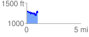
 1.027736 mi
 184.26 ft
 224.01 ft
 -39.75 ft
 4.13 %
GPX Downloads: Track Route
![]()
|
| at: |
Talladega National Forest |
show on map
animate
1.027736 mi
184.26 ft
224.01 ft
-39.75 ft
4.13 %