|
| at: |
Talladega National Forest |
Data from USFS GIS
 show on map
 animate
Trail users:


Elevation Profile
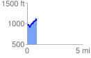
 0.873397 mi
 235.22 ft
 149.61 ft
 85.61 ft
 5.10 %
GPX Downloads: Track Route
![]()
|
| at: |
Talladega National Forest |
show on map
animate
0.873397 mi
235.22 ft
149.61 ft
85.61 ft
5.10 %