|
| at: |
Talladega National Forest |
Data from USFS GIS
 show on map
 animate
Trail users:


Elevation Profile
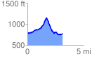
 3.143264 mi
 601.92 ft
 598.69 ft
 3.23 ft
 3.63 %
GPX Downloads: Track Route
![]()
|
| at: |
Talladega National Forest |
show on map
animate
3.143264 mi
601.92 ft
598.69 ft
3.23 ft
3.63 %