|
| at: |
Talladega National Forest |
Data from USFS GIS
 show on map
 animate
Trail users:


Elevation Profile
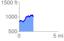
 1.811238 mi
 514.59 ft
 345.43 ft
 169.16 ft
 5.38 %
GPX Downloads: Track Route
![]()
|
| at: |
Talladega National Forest |
show on map
animate
1.811238 mi
514.59 ft
345.43 ft
169.16 ft
5.38 %