|
| at: |
Talladega National Forest |
Data from USFS GIS
 show on map
 animate
Trail users:


Elevation Profile
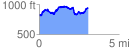
 3.116816 mi
 705.16 ft
 549.38 ft
 155.78 ft
 4.28 %
GPX Downloads: Track Route
![]()
|
| at: |
Talladega National Forest |
show on map
animate
3.116816 mi
705.16 ft
549.38 ft
155.78 ft
4.28 %