| at: |
Camp Wahsega |
Data from David Muse
 show on map
 animate
Trail users:

Elevation Profile
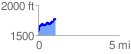
 1.169640 mi
 388.90 ft
 169.32 ft
 219.59 ft
 6.30 %
GPX Downloads: Track Route
![]()
| at: |
Camp Wahsega |
show on map
animate
1.169640 mi
388.90 ft
169.32 ft
219.59 ft
6.30 %