|
| at: |
Talladega National Forest |
Data from USFS GIS
 show on map
 animate
Trail users:


Elevation Profile
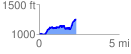
 2.335477 mi
 478.91 ft
 249.28 ft
 229.63 ft
 3.88 %
GPX Downloads: Track Route
![]()
|
| at: |
Talladega National Forest |
show on map
animate
2.335477 mi
478.91 ft
249.28 ft
229.63 ft
3.88 %