|
| at: |
Talladega National Forest |
Data from USFS GIS
 show on map
 animate
Trail users:


Elevation Profile
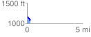
 0.285374 mi
 36.48 ft
 87.92 ft
 -51.44 ft
 5.83 %
GPX Downloads: Track Route
![]()
|
| at: |
Talladega National Forest |
show on map
animate
0.285374 mi
36.48 ft
87.92 ft
-51.44 ft
5.83 %