|
| at: |
Talladega National Forest |
Data from USFS GIS
 show on map
 animate
Trail users:


Elevation Profile
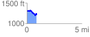
 0.898246 mi
 114.25 ft
 192.14 ft
 -77.89 ft
 4.05 %
GPX Downloads: Track Route
![]()
|
| at: |
Talladega National Forest |
show on map
animate
0.898246 mi
114.25 ft
192.14 ft
-77.89 ft
4.05 %