|
| at: |
Talladega National Forest |
Data from USFS GIS
 show on map
 animate
Trail users:


Elevation Profile
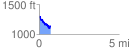
 0.746488 mi
 83.18 ft
 231.58 ft
 -148.41 ft
 5.88 %
GPX Downloads: Track Route
![]()
|
| at: |
Talladega National Forest |
show on map
animate
0.746488 mi
83.18 ft
231.58 ft
-148.41 ft
5.88 %