|
| at: |
Talladega National Forest |
Data from USFS GIS
 show on map
 animate
Trail users:


Elevation Profile
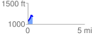
 0.418097 mi
 158.95 ft
 45.25 ft
 113.70 ft
 7.20 %
GPX Downloads: Track Route
![]()
|
| at: |
Talladega National Forest |
show on map
animate
0.418097 mi
158.95 ft
45.25 ft
113.70 ft
7.20 %