|
| at: |
Talladega National Forest |
Data from USFS GIS
 show on map
 animate
Trail users:


Elevation Profile
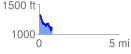
 0.826167 mi
 148.07 ft
 322.18 ft
 -174.11 ft
 7.39 %
GPX Downloads: Track Route
![]()
|
| at: |
Talladega National Forest |
show on map
animate
0.826167 mi
148.07 ft
322.18 ft
-174.11 ft
7.39 %