|
| at: |
Talladega National Forest |
Data from USFS GIS
 show on map
 animate
Trail users:


Elevation Profile
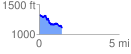
 1.438616 mi
 124.01 ft
 344.78 ft
 -220.77 ft
 4.54 %
GPX Downloads: Track Route
![]()
|
| at: |
Talladega National Forest |
show on map
animate
1.438616 mi
124.01 ft
344.78 ft
-220.77 ft
4.54 %