|
| at: |
Talladega National Forest |
Data from USFS GIS
 show on map
 animate
Trail users:


Elevation Profile
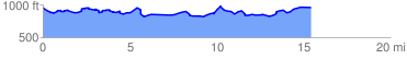
 15.705215 mi
 1181.72 ft
 1242.32 ft
 -60.60 ft
 1.50 %
GPX Downloads: Track Route
![]()
|
| at: |
Talladega National Forest |
show on map
animate
15.705215 mi
1181.72 ft
1242.32 ft
-60.60 ft
1.50 %