|
| at: |
Talladega National Forest |
Data from USFS GIS
 show on map
 animate
Trail users:


Elevation Profile
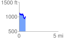
 0.837265 mi
 182.18 ft
 304.74 ft
 -122.56 ft
 6.89 %
GPX Downloads: Track Route
![]()
|
| at: |
Talladega National Forest |
show on map
animate
0.837265 mi
182.18 ft
304.74 ft
-122.56 ft
6.89 %