|
| at: |
Talladega National Forest |
Data from USFS GIS
 show on map
 animate
Trail users:


Elevation Profile
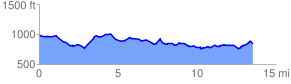
 13.642364 mi
 1180.90 ft
 1348.96 ft
 -168.06 ft
 1.87 %
GPX Downloads: Track Route
![]()
|
| at: |
Talladega National Forest |
show on map
animate
13.642364 mi
1180.90 ft
1348.96 ft
-168.06 ft
1.87 %