|
| at: |
Talladega National Forest |
Data from USFS GIS
 show on map
 animate
Trail users:


Elevation Profile
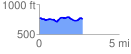
 2.758931 mi
 176.40 ft
 202.93 ft
 -26.53 ft
 1.39 %
GPX Downloads: Track Route
![]()
|
| at: |
Talladega National Forest |
show on map
animate
2.758931 mi
176.40 ft
202.93 ft
-26.53 ft
1.39 %