|
| at: |
Talladega National Forest |
Data from USFS GIS
 show on map
 animate
Trail users:


Elevation Profile
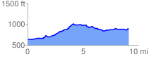
 9.254291 mi
 1050.30 ft
 803.17 ft
 247.13 ft
 2.15 %
GPX Downloads: Track Route
![]()
|
| at: |
Talladega National Forest |
show on map
animate
9.254291 mi
1050.30 ft
803.17 ft
247.13 ft
2.15 %