|
| at: |
Talladega National Forest |
Data from USFS GIS
 show on map
 animate
Trail users:


Elevation Profile
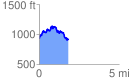
 1.830107 mi
 439.47 ft
 438.80 ft
 0.66 ft
 4.55 %
GPX Downloads: Track Route
![]()
|
| at: |
Talladega National Forest |
show on map
animate
1.830107 mi
439.47 ft
438.80 ft
0.66 ft
4.55 %