|
| at: |
Talladega National Forest |
Data from USFS GIS
 show on map
 animate
Trail users:


Elevation Profile
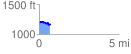
 0.701846 mi
 64.00 ft
 108.29 ft
 -44.29 ft
 2.92 %
GPX Downloads: Track Route
![]()
|
| at: |
Talladega National Forest |
show on map
animate
0.701846 mi
64.00 ft
108.29 ft
-44.29 ft
2.92 %