|
| at: |
Talladega National Forest |
Data from USFS GIS
 show on map
 animate
Trail users:


Elevation Profile
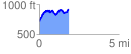
 1.881881 mi
 656.41 ft
 467.31 ft
 189.10 ft
 6.61 %
GPX Downloads: Track Route
![]()
|
| at: |
Talladega National Forest |
show on map
animate
1.881881 mi
656.41 ft
467.31 ft
189.10 ft
6.61 %