|
| at: |
Talladega National Forest |
Data from USFS GIS
 show on map
 animate
Trail users:


Elevation Profile
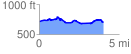
 4.026072 mi
 286.10 ft
 280.79 ft
 5.31 ft
 1.35 %
GPX Downloads: Track Route
![]()
|
| at: |
Talladega National Forest |
show on map
animate
4.026072 mi
286.10 ft
280.79 ft
5.31 ft
1.35 %