|
| at: |
Talladega National Forest |
Data from USFS GIS
 show on map
 animate
Trail users:


Elevation Profile
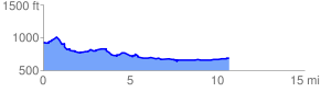
 10.854196 mi
 513.07 ft
 732.14 ft
 -219.06 ft
 1.28 %
GPX Downloads: Track Route
![]()
|
| at: |
Talladega National Forest |
show on map
animate
10.854196 mi
513.07 ft
732.14 ft
-219.06 ft
1.28 %