|
| at: |
Talladega National Forest |
Data from USFS GIS
 show on map
 animate
Trail users:


Elevation Profile
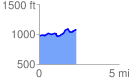
 2.303773 mi
 237.24 ft
 141.39 ft
 95.86 ft
 1.95 %
GPX Downloads: Track Route
![]()
|
| at: |
Talladega National Forest |
show on map
animate
2.303773 mi
237.24 ft
141.39 ft
95.86 ft
1.95 %