|
| at: |
Talladega National Forest |
Data from USFS GIS
 show on map
 animate
Trail users:


Elevation Profile
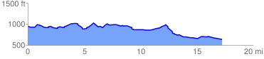
 17.806501 mi
 1031.35 ft
 1349.43 ft
 -318.08 ft
 1.44 %
GPX Downloads: Track Route
![]()
|
| at: |
Talladega National Forest |
show on map
animate
17.806501 mi
1031.35 ft
1349.43 ft
-318.08 ft
1.44 %