|
| at: |
Blue Ridge WMA Bull/Jake Mountain |
Data from David Muse
 show on map
 animate
This road is not marked in the field or on USFS maps as FS28C, but the USFS GIS data calls it FS28C. There is a road marked FS28C off of FS28-2 that ultimately leads to Bearden Falls.
Trail users:


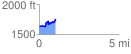
Elevation Profile
 1.009471 mi
 223.40 ft
 111.18 ft
 112.22 ft
 4.19 %
GPX Downloads: Track Route