|
| at: |
Talladega National Forest |
Data from USFS GIS
 show on map
 animate
Trail users:


Elevation Profile
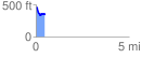
 0.488970 mi
 31.62 ft
 155.64 ft
 -124.02 ft
 6.03 %
GPX Downloads: Track Route
![]()
|
| at: |
Talladega National Forest |
show on map
animate
0.488970 mi
31.62 ft
155.64 ft
-124.02 ft
6.03 %