|
| at: |
Talladega National Forest |
Data from USFS GIS
 show on map
 animate
Trail users:


Elevation Profile
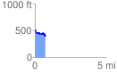
 0.732700 mi
 52.05 ft
 202.39 ft
 -150.34 ft
 5.23 %
GPX Downloads: Track Route
![]()
|
| at: |
Talladega National Forest |
show on map
animate
0.732700 mi
52.05 ft
202.39 ft
-150.34 ft
5.23 %