|
| at: |
Talladega National Forest |
Data from USFS GIS
 show on map
 animate
Trail users:


Elevation Profile
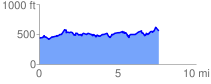
 7.699138 mi
 1068.38 ft
 987.35 ft
 81.03 ft
 2.63 %
GPX Downloads: Track Route
![]()
|
| at: |
Talladega National Forest |
show on map
animate
7.699138 mi
1068.38 ft
987.35 ft
81.03 ft
2.63 %