|
| at: |
Talladega National Forest |
Data from USFS GIS
 show on map
 animate
Trail users:


Elevation Profile
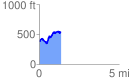
 1.395911 mi
 297.92 ft
 154.61 ft
 143.31 ft
 4.04 %
GPX Downloads: Track Route
![]()
|
| at: |
Talladega National Forest |
show on map
animate
1.395911 mi
297.92 ft
154.61 ft
143.31 ft
4.04 %