|
| at: |
Talladega National Forest |
Data from USFS GIS
 show on map
 animate
Trail users:


Elevation Profile
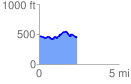
 2.373510 mi
 235.14 ft
 243.99 ft
 -8.85 ft
 1.95 %
GPX Downloads: Track Route
![]()
|
| at: |
Talladega National Forest |
show on map
animate
2.373510 mi
235.14 ft
243.99 ft
-8.85 ft
1.95 %