|
| at: |
Talladega National Forest |
Data from USFS GIS
 show on map
 animate
Trail users:


Elevation Profile
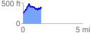
 1.547056 mi
 390.79 ft
 290.93 ft
 99.85 ft
 4.78 %
GPX Downloads: Track Route
![]()
|
| at: |
Talladega National Forest |
show on map
animate
1.547056 mi
390.79 ft
290.93 ft
99.85 ft
4.78 %