|
| at: |
Talladega National Forest |
Data from USFS GIS
 show on map
 animate
Trail users:


Elevation Profile
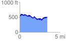
 3.428927 mi
 463.26 ft
 503.89 ft
 -40.63 ft
 2.78 %
GPX Downloads: Track Route
![]()
|
| at: |
Talladega National Forest |
show on map
animate
3.428927 mi
463.26 ft
503.89 ft
-40.63 ft
2.78 %