| at: |
Blue Ridge WMA Bull/Jake Mountain |
Data from David Muse
 show on map
 animate
Trail users:


Elevation Profile
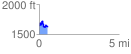
 0.529016 mi
 133.36 ft
 180.05 ft
 -46.69 ft
 6.45 %
GPX Downloads: Track Route
![]()
| at: |
Blue Ridge WMA Bull/Jake Mountain |
show on map
animate
0.529016 mi
133.36 ft
180.05 ft
-46.69 ft
6.45 %