|
| at: |
Talladega National Forest |
Data from USFS GIS
 show on map
 animate
Trail users:


Elevation Profile
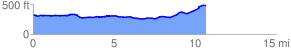
 10.912849 mi
 480.99 ft
 306.44 ft
 174.55 ft
 0.83 %
GPX Downloads: Track Route
![]()
|
| at: |
Talladega National Forest |
show on map
animate
10.912849 mi
480.99 ft
306.44 ft
174.55 ft
0.83 %