|
| at: |
Talladega National Forest |
Data from USFS GIS
 show on map
 animate
Trail users:


Elevation Profile
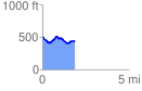
 1.876707 mi
 156.44 ft
 227.67 ft
 -71.23 ft
 2.30 %
GPX Downloads: Track Route
![]()
|
| at: |
Talladega National Forest |
show on map
animate
1.876707 mi
156.44 ft
227.67 ft
-71.23 ft
2.30 %