|
| at: |
Talladega National Forest |
Data from USFS GIS
 show on map
 animate
Trail users:


Elevation Profile
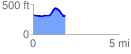
 1.863515 mi
 152.26 ft
 157.63 ft
 -5.36 ft
 1.60 %
GPX Downloads: Track Route
![]()
|
| at: |
Talladega National Forest |
show on map
animate
1.863515 mi
152.26 ft
157.63 ft
-5.36 ft
1.60 %