|
| at: |
Talladega National Forest |
Data from USFS GIS
 show on map
 animate
Trail users:


Elevation Profile
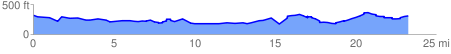
 23.521025 mi
 1415.02 ft
 1445.13 ft
 -30.11 ft
 1.16 %
GPX Downloads: Track Route
![]()
|
| at: |
Talladega National Forest |
show on map
animate
23.521025 mi
1415.02 ft
1445.13 ft
-30.11 ft
1.16 %