|
| at: |
Talladega National Forest |
Data from USFS GIS
 show on map
 animate
Trail users:


Elevation Profile
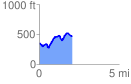
 2.076270 mi
 403.74 ft
 281.21 ft
 122.53 ft
 3.68 %
GPX Downloads: Track Route
![]()
|
| at: |
Talladega National Forest |
show on map
animate
2.076270 mi
403.74 ft
281.21 ft
122.53 ft
3.68 %