| at: |
Talladega National Forest |
Data from USFS GIS
 show on map
 animate
Trail users:


Elevation Profile
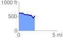
 2.086697 mi
 156.99 ft
 240.52 ft
 -83.53 ft
 2.18 %
GPX Downloads: Track Route
![]()
| at: |
Talladega National Forest |
show on map
animate
2.086697 mi
156.99 ft
240.52 ft
-83.53 ft
2.18 %