| at: |
Talladega National Forest |
Data from USFS GIS
 show on map
 animate
Trail users:


Elevation Profile
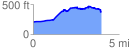
 4.005113 mi
 515.97 ft
 359.75 ft
 156.22 ft
 2.44 %
GPX Downloads: Track Route
![]()
| at: |
Talladega National Forest |
show on map
animate
4.005113 mi
515.97 ft
359.75 ft
156.22 ft
2.44 %