| at: |
Talladega National Forest |
Data from USFS GIS
 show on map
 animate
Trail users:


Elevation Profile
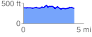
 4.210977 mi
 285.89 ft
 304.99 ft
 -19.10 ft
 1.37 %
GPX Downloads: Track Route
![]()
| at: |
Talladega National Forest |
show on map
animate
4.210977 mi
285.89 ft
304.99 ft
-19.10 ft
1.37 %