| at: |
Talladega National Forest |
Data from USFS GIS
 show on map
 animate
Trail users:


Elevation Profile
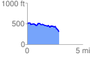
 2.882257 mi
 211.83 ft
 402.14 ft
 -190.31 ft
 2.64 %
GPX Downloads: Track Route
![]()
| at: |
Talladega National Forest |
show on map
animate
2.882257 mi
211.83 ft
402.14 ft
-190.31 ft
2.64 %