|
| at: |
Talladega National Forest |
Data from USFS GIS
 show on map
 animate
Trail users:


Elevation Profile
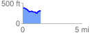
 1.523938 mi
 101.34 ft
 160.27 ft
 -58.93 ft
 1.99 %
GPX Downloads: Track Route
![]()
|
| at: |
Talladega National Forest |
show on map
animate
1.523938 mi
101.34 ft
160.27 ft
-58.93 ft
1.99 %