| at: |
Talladega National Forest |
Data from USFS GIS
 show on map
 animate
Trail users:


Elevation Profile
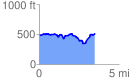
 3.545037 mi
 396.34 ft
 374.19 ft
 22.15 ft
 2.12 %
GPX Downloads: Track Route
![]()
| at: |
Talladega National Forest |
show on map
animate
3.545037 mi
396.34 ft
374.19 ft
22.15 ft
2.12 %