| at: |
Talladega National Forest |
Data from USFS GIS
 show on map
 animate
Trail users:


Elevation Profile
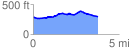
 3.793084 mi
 219.81 ft
 214.93 ft
 4.89 ft
 1.10 %
GPX Downloads: Track Route
![]()
| at: |
Talladega National Forest |
show on map
animate
3.793084 mi
219.81 ft
214.93 ft
4.89 ft
1.10 %