| at: |
Talladega National Forest |
Data from USFS GIS
 show on map
 animate
Trail users:


Elevation Profile
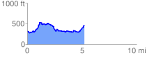
 5.285067 mi
 679.34 ft
 545.07 ft
 134.27 ft
 2.43 %
GPX Downloads: Track Route
![]()
| at: |
Talladega National Forest |
show on map
animate
5.285067 mi
679.34 ft
545.07 ft
134.27 ft
2.43 %