|
| at: |
Talladega National Forest |
Data from USFS GIS
 show on map
 animate
Trail users:


Elevation Profile
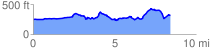
 8.580664 mi
 851.39 ft
 833.30 ft
 18.09 ft
 1.88 %
GPX Downloads: Track Route
![]()
|
| at: |
Talladega National Forest |
show on map
animate
8.580664 mi
851.39 ft
833.30 ft
18.09 ft
1.88 %