|
| at: |
Talladega National Forest |
Data from USFS GIS
 show on map
 animate
Trail users:


Elevation Profile
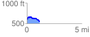
 1.154394 mi
 99.69 ft
 146.36 ft
 -46.67 ft
 2.40 %
GPX Downloads: Track Route
![]()
|
| at: |
Talladega National Forest |
show on map
animate
1.154394 mi
99.69 ft
146.36 ft
-46.67 ft
2.40 %