|
| at: |
Talladega National Forest |
Data from USFS GIS
 show on map
 animate
Trail users:


Elevation Profile
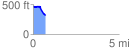
 0.701577 mi
 26.74 ft
 162.41 ft
 -135.67 ft
 4.38 %
GPX Downloads: Track Route
![]()
|
| at: |
Talladega National Forest |
show on map
animate
0.701577 mi
26.74 ft
162.41 ft
-135.67 ft
4.38 %